


Storm Jocelyn set to bring further periods of high winds to the north-east this week
Register for free to read more of the latest local news. It's easy and will only take a moment.

As the winds ease and the clean-up continues following Storm Isha, Met Eireann has named Storm Jocelyn which will bring strong winds and rain to Northern Ireland and much of Britain.
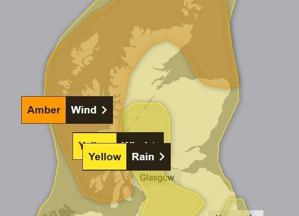
A strong jet stream is pushing another large-scale, low-pressure system from the Atlantic across northern Scotland bringing wet and windy weather for Tuesday night and into Wednesday for much of the northern half of the country. Amber and yellow National Severe Weather warnings for wind have been issued covering much of the UK together with yellow warnings for rain covering parts of western and southern Scotland, and northwest England.
A spell of strong west or southwesterly winds associated with Storm Jocelyn is expected to affect parts of western and northern Scotland during Tuesday evening and night. Winds are likely to gust 55-65 mph quite widely while there is potential for gusts of 75 to 80 mph in a few places, in particular exposed parts of the Western Isles and coastal northern Scotland. Winds will slowly ease from the west during Wednesday morning
Following the impacts caused by Storm Isha resilience is expected to be lower and it may also hamper any ongoing recovery and repair efforts.
Met Office Chief Meteorologist, Steve Willington, said: “Although this system will be a step down relative to Storm Isha, with the damage and clean up still underway, we could potentially see more impacts from Storm Jocelyn.
“Outbreaks of heavy rain on Tuesday could bring rainfall accumulations of 15 to 20 mm quite widely with 40 to 50 mm over higher ground in southwest Scotland, the Scottish Highlands and parts of northwest England.
"Wind gusts are expected to reach 55 to 65 mph across northwestern Scotland while there is potential for winds to gust to 75 to 80 mph in a few places, in particular exposed parts of the Western Isles and coastal northwest Scotland early on Wednesday morning.”
The winds will gradually ease through the Wednesday and as we head through the rest of the week the weather continues to look changeable, with the drier and most settled conditions towards the south and east, and the most unsettled (wettest and windiest) conditions expected in the northwest.
Temperatures are expected to remain mild or close to average for the time of year.
Martin Thomson, National Operations Manager for Resilience at Transport Scotland said: “The trunk road network is recovering well from the worst impacts of Storm Isha. Some roads and bridges do remain disrupted and so please continue to check before you travel until conditions improve and the clear-up is complete.
“Focus will soon shift to the next named storm, Jocelyn, for later this week, and preparations are already underway with rail, aviation and ferries colleagues to ensure we are as ready as we can be.
“The public can play its part and plan ahead by visiting www.traffic.gov.scot. Staff from our trunk road operating companies will be patrolling the network and undertaking inspections to respond quickly to any further treefall or blocked drains. Their proactive efforts in terms of branch cutting and drain clearing at vulnerable locations has helped minimise disruption in the past.
“Across the wider network, we can expect to see more delays and cancellations with ferries, flights and rail from Tuesday into Wednesday morning. Please check with your public transport operator for the latest information and your local authority and Police Scotland for the latest information on local roads.”