


North Atlantic temperature anomaly sparks concern among climate scientists
Register for free to read more of the latest local news. It's easy and will only take a moment.
A sea surface temperature anomaly in the North Atlantic has scientists working to understand how record high warmth for this time of year could have occurred.
Changing wind patterns, global warming, a lack of Saharan dust or a combination of all three have been suggested, with questions raised about how the anomaly will affect atmospheric temperatures and weather.
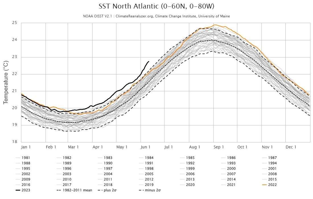
In early March, the North Atlantic temperature rose above previous records and is now 1C warmer than the 1981-2011 mean average for this time of year, according to data from the National Oceanic and Atmospheric Administration (NOAA) and presented by the University of Maine.
The most recent record is June 11 at 22.7C, which passes the previous record for the same day in 2010 by 0.5C.
The North Atlantic usually heats up throughout the summer and peaks at the end of August, but scientists are unsure exactly why this year is such an outlier and whether it will continue.
Dr Melissa Lazenby, lecturer in climate change at the University of Sussex, believes these record temperatures are a combination of a change in atmospheric wind patterns and long-term warming of the ocean from human emissions.
She said: “There is a blocking high pressure system over the northern parts of the Atlantic in the higher and lower parts of the atmosphere, which is causing the circulation to be different from the typical climatology, which is a low-pressure system in the north Atlantic.
“The change from a low pressure to a high pressure means the dominating trade winds over the subtropical Atlantic are westerly instead of the normal trade easterly winds.
“This change in wind direction results in more ocean warming over the region.”
Professor Michael Man of the University of Pennsylvania suggested on social media that a lack of Saharan dust, which normally has a cooling effect on the oceans, could also be at play.
He stressed that the anomaly “underscores the interplay between human-caused warming and natural variability”.
Dr Lazenby said: “Anthropogenic climate change is playing a part in this as oceans are now warmer due to our emissions and El Nino events are being affected by climate change through more extreme El Nino events and therefore cannot be viewed as a separate driver of isolated events.”
El Nino is a naturally-occurring phenomenon defined by warmer-than-average sea surface temperatures in the Pacific Ocean, which influence atmospheric temperature and global weather patterns.
Scientists believe the current El Nino will likely combine with human-induced warming to push the annual global average temperature beyond 1.5C for the first time on record.
It is unclear what relationship will form between El Nino and the current warming of the North Atlantic.
Dr Jon Robson, a meteorologist at the University of Reading, said: “For the global temperatures next year, I think El Nino will dominate that.
“The last few years in the North Atlantic have been pretty warm, so it could contribute to continuing warm global temperatures, but El Nino will be much bigger.
“One of the questions in my mind is what the emphasis will be on the tropical cyclones – the hurricanes.
“Warmer sea surface temperatures in the tropical North Atlantic are normally associated with more storms.
“What normally happens though in an El Nino year is those Atlantic hurricanes are suppressed. So there’s a bit of a fight going on at the moment.”
Dr Lazenby added: “Warmer oceans provide more available energy for the tropical systems and can cause stronger storms if other factors allow it.
“However, this does not mean that there will be more landfalls, as that depends on the overall pressure patterns and steering mechanisms.
“It is well known that El Nino events reduce the number of hurricanes and tropical systems overall in the Atlantic.
“The reason is stronger wind shear, preventing the storms from organising and powering up vertically.
“Therefore, this could indicate that despite the supportive ocean conditions, the atmosphere may not allow an intense hurricane season as El Nino is active.”