


Amber warning issued by Met Office as Storm Babet approaches
Register for free to read more of the latest local news. It's easy and will only take a moment.

The Met Office has issued an amber warning as Storm Babet approaches which will bring disruptive rain and strong winds in the coming days.
The influence of Storm Babet will begin to be felt late on Tuesday and into Wednesday as heavy and, in places, disruptive rainfall will move in from the south and west, impacting Northern Ireland and much of England and Wales.
As the rain moves northwards it will stall across central and eastern parts of Scotland where the rain will become heavy and persistent from Thursday through to Saturday.
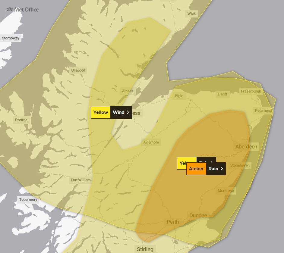
There is an amber severe weather warning for rain for this area where up to 150-200 mm of rain could accumulate in some areas of higher ground.
Strong south-easterly winds will also create dangerous conditions along the east coast of the UK, with large waves an additional hazard.
A number of weather warnings are in force for Storm Babet, with heavy rain also likely for Northern Ireland, as well as large parts of England and Scotland.
Met Office deputy chief meteorologist Tony Wardle said: “Storm Babet will bring disruption for parts of the UK in the coming days, with heavy rain and strong winds likely for many.
“Heavy and persistent rain will fall onto already saturated ground bringing a risk of flooding. It is important to stay up to date with warnings from your local flood warning agency as well as the local authorities.
“As well as heavy rain, Storm Babet will bring some very strong winds and large waves near some eastern coasts too.
"Gusts around 70 mph are possible in eastern and northern Scotland from Thursday. Met Office warnings will continue to be reviewed as the forecast develops.”
David Morgan, flood duty manager for the Scottish Environment Protection Agency (SEPA), said: “Storm Babet will bring heavy rain and high winds across Scotland from Wednesday evening, starting in the south-west before moving across to the north-east through Thursday and into the weekend.
“Impacts from surface water and rivers are likely, and with catchments saturated from recent heavy rain and flooding, we’re urging people to be prepared for potential flooding.
"There is also concern that surface-water flooding may be exacerbated by debris blocking drainage and culverts as a result of the high winds.
“Flood alerts and warnings will be issued as required, and we continue to work with the Met Office to monitor the situation 24/7.
"People can check our flood updates for all the latest information and the three-day Scottish flood forecast to see what conditions are expected further ahead.
“If you live or work in an area that could be affected, consider any steps you need to take now to be prepared and stay safe, and to take extra care if you need to travel.
“If you have not already signed up to Floodline, you can do so now to receive free updates for where you live, or travel through, directly to your phone. Follow SEPA’s social media, especially @SEPAflood on X for the latest information.”
RNLI water safety partner Sam Hughes said: “The forecasted strong winds along with heavy rain are likely to cause dangerous conditions for those visiting the coast around the UK and Ireland.
“The RNLI advises staying a safe distance away from the water and cliff edges as the conditions could knock you off your feet or wash you into the sea. It is not worth risking your life.
“If you see someone else in danger in the water, call 999 or 112 and ask for the Coastguard if by the coast, or the fire service if inland. If you have something that floats that they can hold on to, throw it to them. Don’t go in the water yourself – you may end up in difficulty too.”
The RNLI advice is:
- Stay well back from stormy, wintery seas and cliff edges.
- Check the weather forecast and tide times before you go out.
- Take a phone with you.
- In an emergency call 999 or 112 and ask for the Coastguard.
Meanwhile, Aberdeenshire Council has urged residents and businesses to get prepared and have protection in place for their properties.
The Met Office has updated its weather warning to amber from around 6am on Thursday until 6pm on Friday – with SEPA also updating its flood warning to amber.
A local authority spokesman said: "There is real potential for heavy and prolonged rainfall – exacerbated by strong south-easterly winds – to affect large parts of Aberdeenshire including the threat of localised flooding through both coastal and river impacts – and communities must start to take precautionary action now.
"The Met Office warning highlights that 70-100mm of rain will fall widely across the area, with some upland areas possibly seeing 150-200mm. That is an incredible amount of rain to fall within a 36 to 48-hour period for this area."
Potential impacts include:
- Extensive flooding to homes and businesses is likely, which could lead to collapse or damage to buildings or structures.
- There is a good chance that communities within flooded areas could be completely cut off, perhaps for several days.
- Fast flowing or deep floodwater is likely, causing a danger to life.
- Power and other essential services, such as gas, water and mobile phone service will probably be lost.
- Road closures are likely, along with bus and train service delays and cancellations.
- Dangerous driving conditions could occur because of spray and flooded roads.
In preparation, Aberdeenshire Council has teams creating significant supplies of sandbags at its roads depots should residents require them – locations can be found at https://bit.ly/AbshireSandbags
Local sandbag stocks may run out and cannot necessarily be replaced.
The spokesman added: "While Aberdeenshire Council has an obligation to maintain roads and undertake certain emergency responses in the event of flooding, this does not extend to private property – residents and businesses should take steps now to protect their own property from flooding.
"If you live in a known flooding area, please ensure you sign-up now for alerts from SEPA call the Floodline on 0345 9881188 or visit http://floodline.sepa.org.uk/floodupdates/"
Roads crews are currently undertaking gully-clearing in known flood-risk areas.
The severity of the winds is likely to have a significant impact on woodland, particularly in areas weakened by previous storms.
While roads and landscape teams will respond to calls about fallen trees, if it is too dangerous – particularly under cover of darkness – the local authority will close roads until it is safe to remove them.
Fallen, overhanging and hung-up trees represent a serious danger to safety and affected areas should be avoided at all times.
To report fallen trees on the roads network call 03456 081205 (during office hours).
Flooding advice is available here: https://floodlinescotland.org.uk/your-home/
Keep an eye on the forecast at https://www.metoffice.gov.uk/weather/warnings-and-advice/uk-warnings#?date=2023-03-06
To get all the latest council updates including impacted waste collection services, facility closures, download the myaberdeenshire app at https://www.aberdeenshire.gov.uk/my/mobile-app/
Useful phone numbers include:
- Power outages – via SSEN on 105.
- Non-urgent medical issues – via NHS on 111.
- Emergency council housing repairs – 03456 08 12 03.
- Emergency social care 03456 08 12 06.